How to increase the precision of L.geoJson with more than 6 decimals #7462
Comments
|
Related: #6681 |
|
The above mentioned link is the resolution for my issue as I didn't get any idea how to resolve my issue after looking at #6681? |
|
Please show sample of your code. L.geoJson({"type": "Feature",
"geometry": {
"type": "Polygon",
"coordinates": [ [ [1.123456789, 2.123456789], [3.123456789, 4.123456789], [5.123456789, 6.123456789] ] ]
}
}); |
|
Please see the blow Sample code of mine. let lyrGroup = new L.featureGroup().addTo(map);
let lyrToMerge = new L.featureGroup().addTo(map);
let data = { "type": "FeatureCollection", "features": [{ "type": "Feature", "geometry": { "type": "Polygon", "coordinates": [[[278657.8499999996, 187313.8000000007], [278652.4000000004, 187304.8499999996], [278652.1840000004, 187304.9810000006], [278650.7429999998, 187302.6699999999], [278649.426, 187302.159], [278646.4589999998, 187303.9460000005], [278646.2290000003, 187305.2449999992], [278646.216, 187305.3169999998], [278647.7000000002, 187307.6999999993], [278653.0999999996, 187316.6999999993], [278657.8499999996, 187313.8000000007]]] }, "properties": {} }] };
L.geoJson(data, {
coordsToLatLng: function (coords) {
let r = GridToLatLng(coords);
return r;
},
onEachFeature: function (feature, layer) {
layer.bindContextMenu({
contextmenu: true, contextmenuItems: [
{
text: "Select", index: 0, callback: function () {
let fc = lyrGroup.toGeoJSON();
L.geoJson(fc, {
onEachFeature: function (feature, layer) {
lyrToMerge.addLayer(layer);
lyrGroup.clearLayers();
}
});
}
}
]
});
}
}).addTo(lyrGroup);
function GridToLatLng(xy) {
let proj4LatLng = proj4("EPSG:27700", "EPSG:4326", xy);
return L.latLng(proj4LatLng[1], proj4LatLng[0]);
}layer values on onEachFeature : |
Why not provide ready-to-run sample with all the required data included? |
|
Here I do not see any problem: let lyrGroup = new L.featureGroup().addTo(map);
let lyrToMerge = new L.featureGroup().addTo(map);
let data = { "type": "FeatureCollection", "features": [{ "type": "Feature", "geometry": { "type": "Polygon", "coordinates": [[[278657.8499999996, 187313.8000000007], [278652.4000000004, 187304.8499999996], [278652.1840000004, 187304.9810000006], [278650.7429999998, 187302.6699999999], [278649.426, 187302.159], [278646.4589999998, 187303.9460000005], [278646.2290000003, 187305.2449999992], [278646.216, 187305.3169999998], [278647.7000000002, 187307.6999999993], [278653.0999999996, 187316.6999999993], [278657.8499999996, 187313.8000000007]]] }, "properties": {} }] };
L.geoJson(data, {
onEachFeature: function (feature, layer) {
debugger;
}
}).addTo(lyrGroup);What is done inside |
|
Try this after your code: console.log(lyrGroup.toGeoJSON().features[0].geometry.coordinates[0]);And compare output with this: console.log(lyrGroup.toGeoJSON(10).features[0].geometry.coordinates[0]);Hint: precision argument. |
Proj4 just convert Actual coordinates into latlng coordinates. I will post an example here shortly. |
yeah sure , I will try passing precision argument in .toGeoJSON |
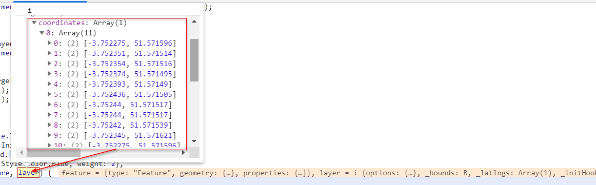
Hi,
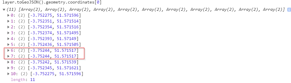
I've a geometry with 16 decimal place coordinates. When I load the features via L.geoJson, leaflet is rounding all values to 5 or 6 decimals. Due to this, some of the coordinates are turn into same value in the coordinate list. As a result, we are not getting the accuracy of the geometry. is there any option where we can increase the decimal place in the leaflet while using L.geoJson?
Original Coordinates in the geometry
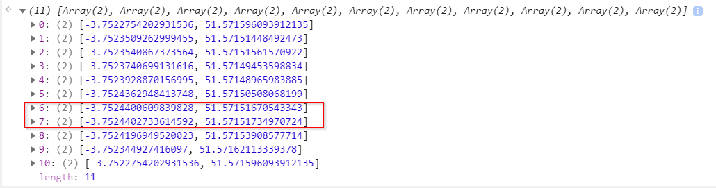
After loading into the layerGroup via L.geoJson
The text was updated successfully, but these errors were encountered: